

Hurricane Laura: Tracking damage through property-level change detection
In a previous post, we analyzed the housing stock in Hurricane Laura’s predicted path to better understand vulnerability ahead of the Category 4 storm. In this update, we will dive into the extensive damage wrought by the storm by tracking changes to property condition, with a specific focus on the hard-hit city of Lake Charles.
At landfall, Hurricane Laura was a high-end Category 4 storm with winds reaching 150 mph, tied as the strongest hurricane to make landfall in Louisiana. As expected, the storm’s intensity decreased as it drove inland but Lake Charles, which sits 30 miles inland, still reported a gust of 137 mph. Though Lake Charles was battered by extremely high winds and 4 feet of storm surge, luckily, the bulk of the predicted and “unsurvivable” 15- to 20-foot storm surge occurred in less populated wetlands. Sadly, 15 people still lost their lives — with more than half of those succumbing to carbon monoxide poisoning related to the use of portable generators due to power outages.
In order to better understand the scope and depth of property damage caused by Hurricane Laura, we ran our property change detection engine across roughly 30,000 homes in Lake Charles, looking specifically at roof damage, via measurable degradation in Cape’s proprietary Roof Condition Rating, as well as changes in tree coverage. This analysis was created by comparing pre- and post-event imagery captured by our partner, Nearmap, in the days following landfall.
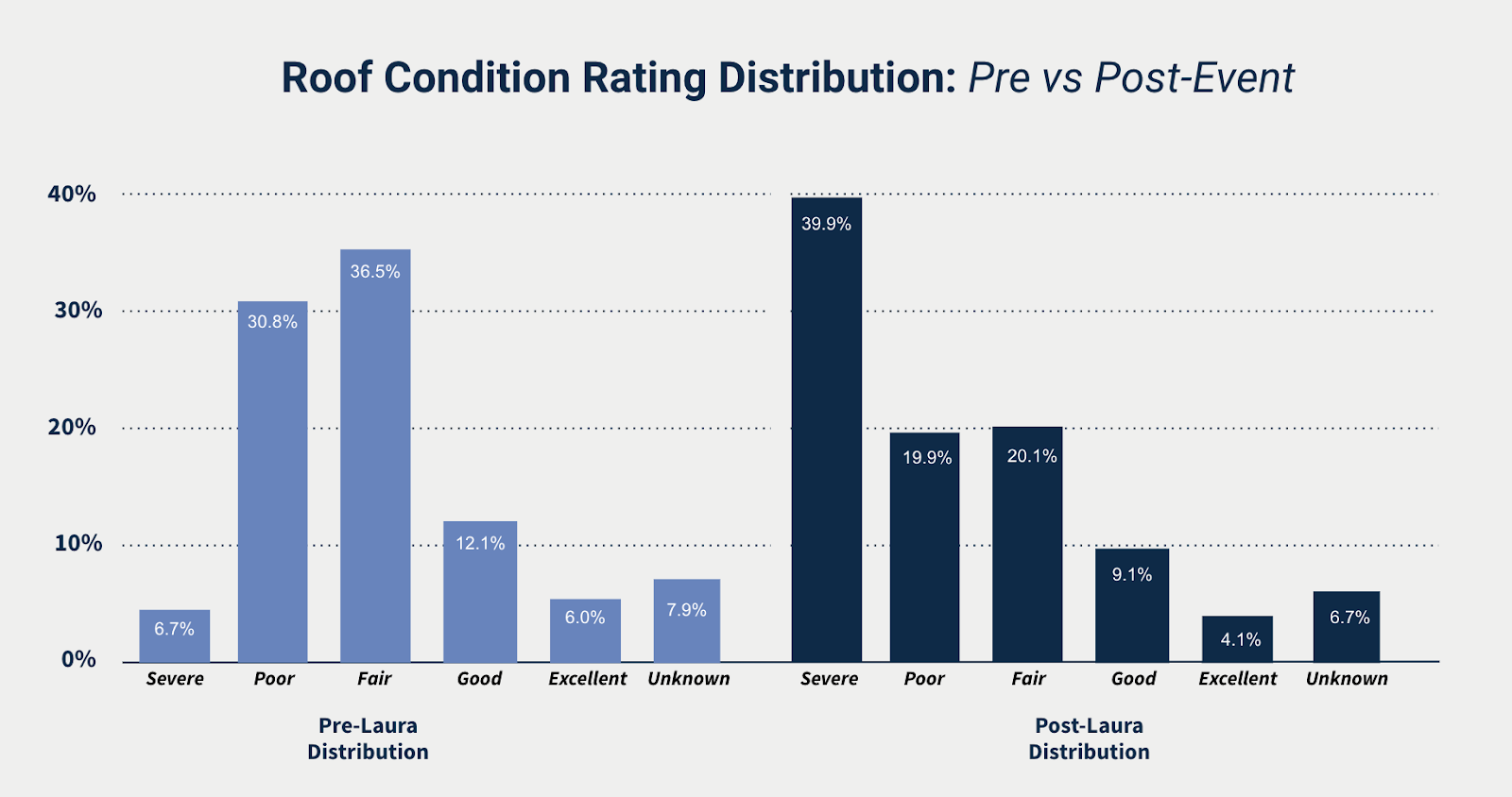
Let’s start by looking at the difference in the distribution of Roof Condition Rating pre- and post-event. The chart below clearly shows the extensive roof damage that occurred — with the post-event distribution (dark blue) skewing heavily towards severe roofs, in comparison to pre-event (light blue). In fact, we identified 10,000 additional homes as having severe roof condition after the storm.
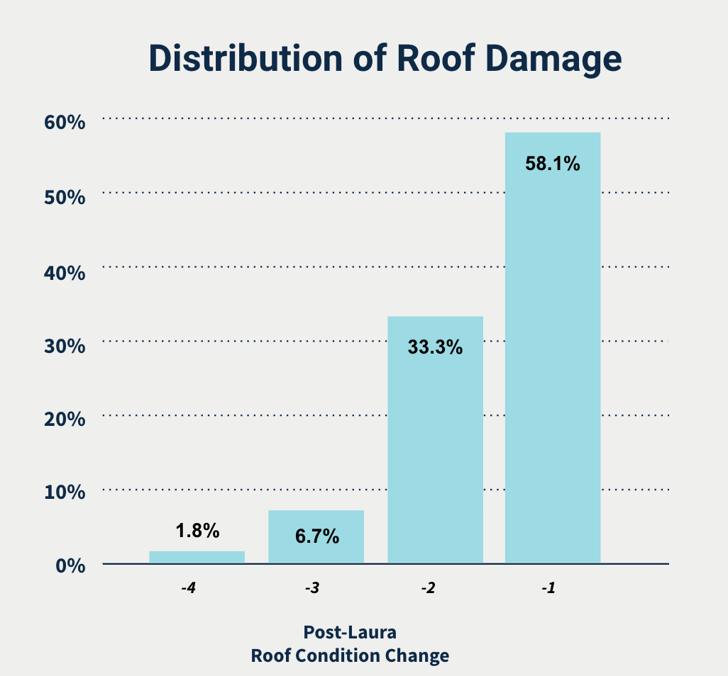
Another way to look at this information is to plot the degree of roof degradation across Lake Charles. In doing so, we see that the large majority of homes saw a one or two-step change from their pre-event condition — in other words, not many homes with good or excellent roof condition became severe, whereas many homes likely fell from poor and fair condition.
This finding is not surprising given the heavy pre-event distribution of homes in the poor and fair categories (over 65% of homes). However, by looking at the proportion of roofs across different categories that ended up falling into severe and poor condition, we can better understand vulnerability to damage based on “pre-existing condition”:
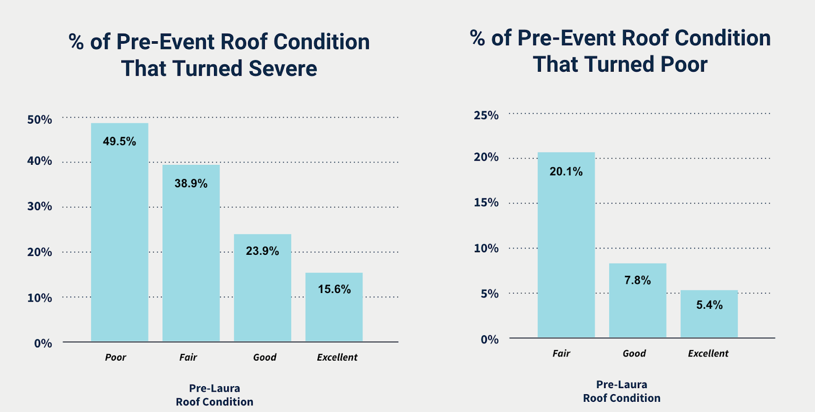
From a risk and loss predictiveness standpoint, there is clear signal across the roof condition categories. For example, poor condition roofs were twice as likely as good roofs to turn severe. Similarly, fair condition roofs were 2.5X as likely as excellent roofs to turn severe. The same can be said for the rate of roofs turning poor, with fair roofs over 2.5X as likely as good roofs to turn poor. These findings are in line with previous studies Cape Analytics has run, including a broad, roof condition loss impact analysis and an analysis of damage incurred from Hurricane Irma in Florida.
Lastly, we looked at changes in tree coverage — focusing on tree limbs overhanging roofs. In previous studies, we found that tree overhang increases claim severity by as much as 90 percent in wind scenarios (tree limbs falling on roofs). Therefore, any substantial decrease in tree overhang after the storm would suggest that trees have been downed and may have caused damage to underlying structures.
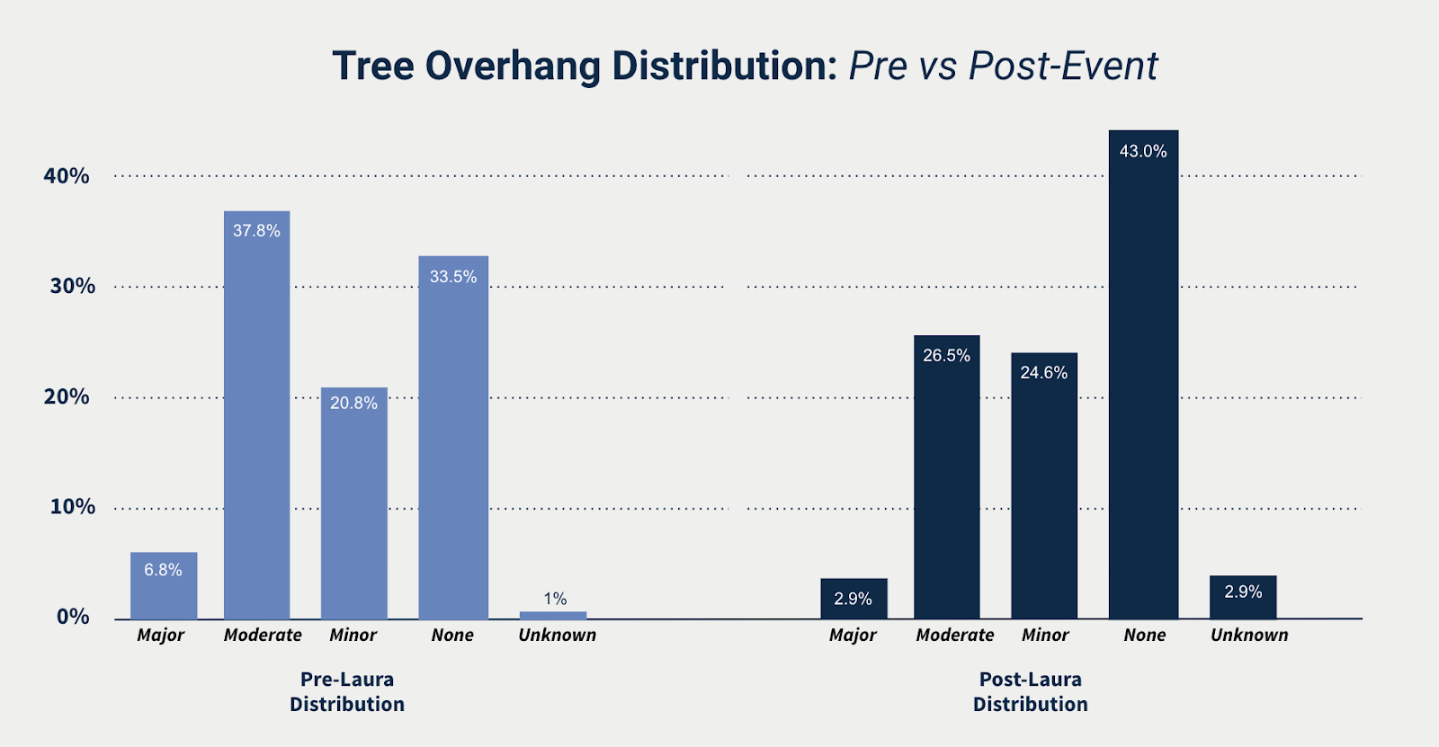
The above bar chart shows exactly that: an additional 4,500 homes with a minor amount of–or no–tree limbs overhanging the roof and a decrease of roughly 4,500 homes with a moderate or major amount of tree coverage hanging over the roof. It’s likely that many of those 4,500 homes sustained some kind of structural damage due to falling tree limbs.
Risk experts have also long believed that there are differences in wind vulnerability between tree species. By comparing tree overhang changes between two events with similar wind speeds, but separate geographies with different flora types, it may be possible to identify a disparity. Comparing Hurricanes Laura and Irma may present an interesting case study, with each delivering gusts up to 137 and 142 mph, respectively. In the case of Hurricane Laura, the Lake Charles area has a much larger prevalence of oaks and pines, which are believed to be more vulnerable to high winds. In areas hit hard by Hurricane Irma, in 2017, varieties of palms trees are the dominant tree type. So we ran the same change analysis of tree overhang across Lee, Collier, and Charlotte counties in Florida, before and after Hurricane Irma, to see if we could spot any differences:

To our surprise, there was indeed a sizable difference between the two storms. In the case of Hurricane Laura, we saw a change in about 15% of the homes in our sample set. With Hurricane Irma, though, changes in tree overhang occurred in just 5% of homes. Differences in vegetation coverage are unlikely to explain this disparity… a much larger proportion of homes in Lake Charles have major or moderate tree coverage, but this does not account for overall change pre- and post-event. Therefore, it seems plausible that fauna type may play a major role. Although not conclusive or exhaustive by any means, these are interesting results that likely deserve further study, especially in high-wind scenarios, when falling tree limbs may be responsible for a considerable portion of structural damage.
The Lake Charles and Louisiana coastline are no stranger to strong storms. But as claims are filed and resolved, and Lake Charles begins to rebuild, the industry should seek to gain a better understanding of the link between pre-event property characteristics such as roof condition and vegetation coverage, damage, and loss. These learnings, in turn, should help inform construction and risk mitigation practices across the Gulf Coast in order to reduce vulnerability to future storms and help homeowners and residents get back on their feet, faster.
Aggregate Statistics Created Using Data Produced from Nearmap Imagery