CAPE Wildfire Risk Rating Highly Predictive During Extreme Marshall Fire

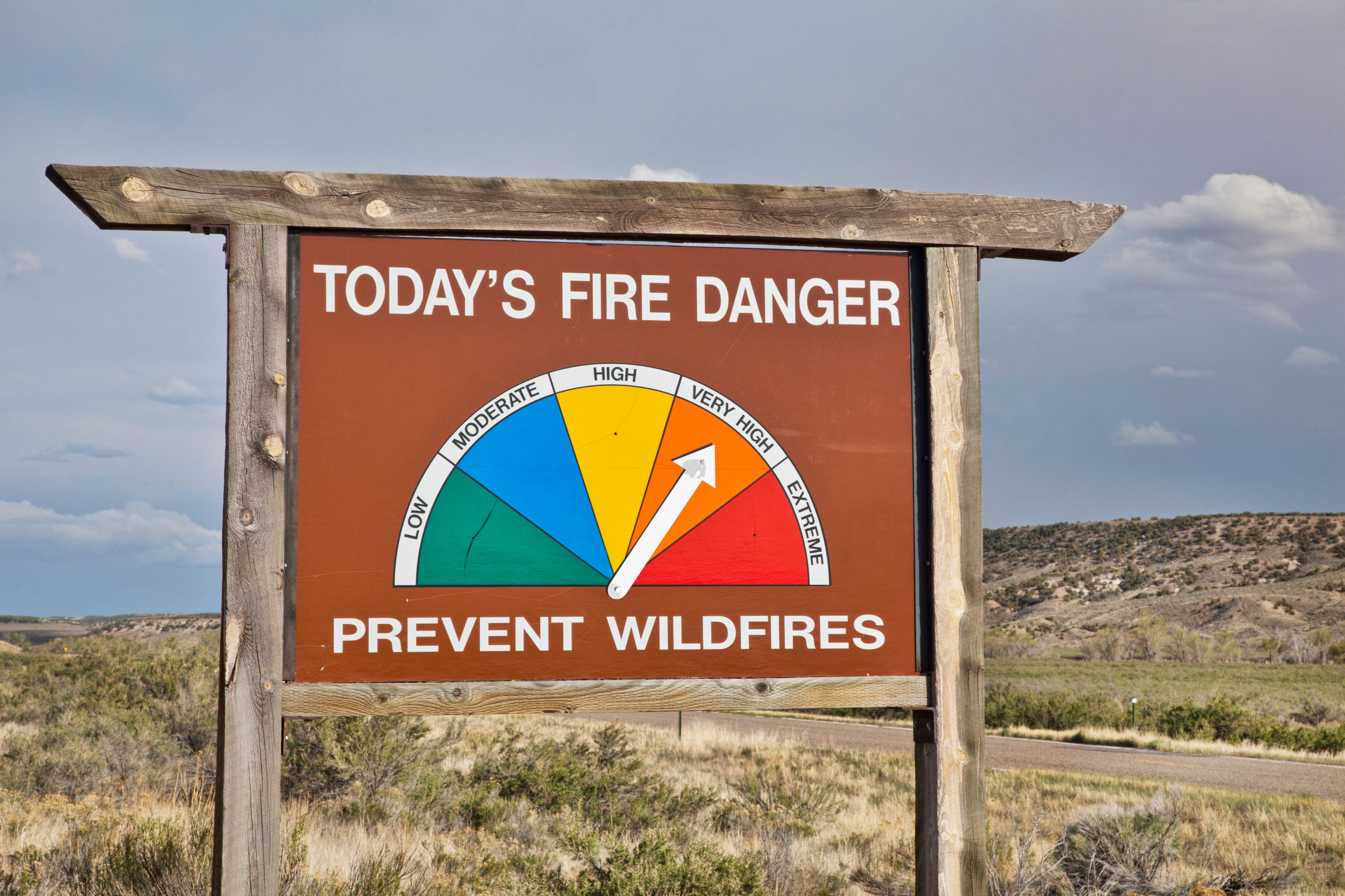
Wildfires have become a mainstay of life in the Western United States, with yearly blazes increasing in both scale and intensity. In late 2021, wildfires near Boulder, Colorado were the latest examples of the threat imposed by these natural disasters.
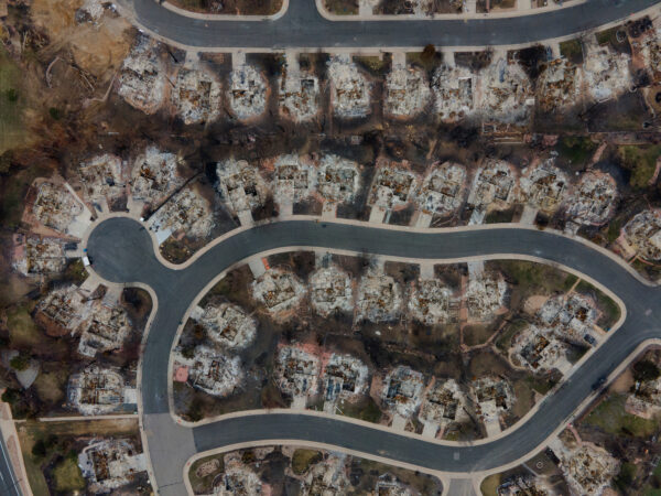
In particular, the severity of the Marshall Fire, located to the northwest of the sprawling Denver metro area, was exacerbated by extreme winds of over 100 miles per hour. Much like the hurricane-force “Diablo winds” that fueled 2017’s Tubbs Fire in Northern California, the Marshall Fire quickly and wildly spread through drought-stricken areas. In the end, the fire burned more than 6,000 acres, destroyed 1,084 residential structures, damaged 149, and caused over a half-billion dollars in damage. While 6,000 acres could be considered a small-sized fire by California standards, a fire with these wind conditions can be extremely destructive and pose a threat to entire subdivisions.
While the dynamics of the Marshall Fire were unique, CAPE Analytics’ own Wildfire Risk Rating was still highly predictive of property risk during this extreme weather event. Digging deeper, CAPE’s findings show the need for a more holistic approach to segmenting wildfire risk.
CAPE’s Wildfire Risk Rating Holds Strong
CAPE’s wildfire solution brings together cutting-edge geospatial AI across multiple imagery providers, with dozens of other wildfire-relevant data sources. A key rating from this suite is CAPE’s Wildfire Risk Rating, which merges regional hazard-level with structure and community-specific vulnerability for the most holistic view of risk available.
The Wildfire Risk Rating consists of five categories of a property’s wildfire risk – Very High, High, Moderate, Low, and Very Low, with additional segmentation available for each rating based on specific vulnerability and risk inputs.
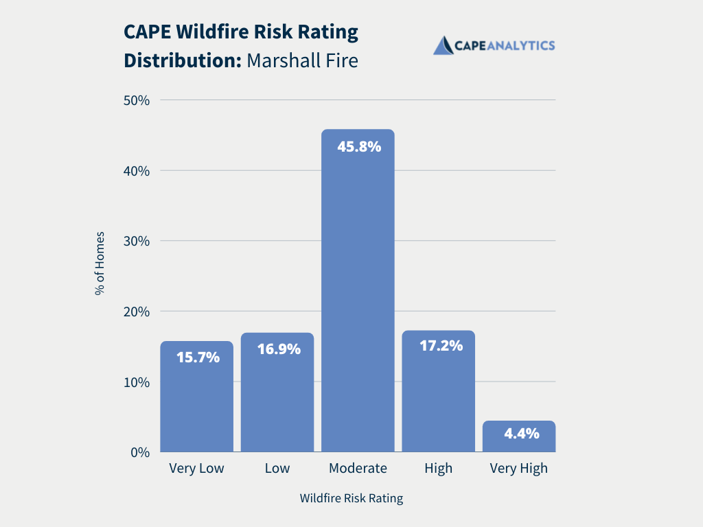
First, let’s take a look at the rating distribution of homes that were in this sample from the Marshall Fire. As you can see below, most homes, 45.8%, were in the Moderate wildfire risk category, with the next closest categories being High and Low risk at 17.2% and 16.9%, respectively.
Combining Risk Assessment Layers
To get an initial baseline in our analysis, we took a look at the Wildfire Hazard Potential score from the USDA Forest Service. We found that 50% of the homes in the sample were classified as Non-Burnable and that 75% were classified as Non-Burnable or Very Low Risk. This rating system showed almost no predictiveness, showing that not all hazard solutions are created equal.
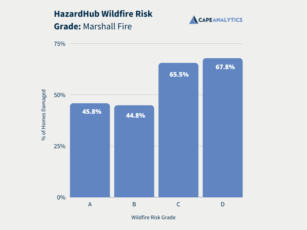
Next, we looked at HazardHub’s Wildfire Risk Grade, which uses a far more holistic approach to better understand the hazard profiles of these properties. As you can see below, this A-F assessment of individual homes was far more predictive of wildfire risk. Homes were either less likely to be damaged in the A and B category or more likely to be damaged in the C and D category. Although it’s a fairly binary segmentation, there is a significant difference in risk between the two groupings. A and B category homes were further away from the vegetative areas where the fire began, with the fire losing some destructiveness as it progressed deeper into the urban landscape.
The final piece of the puzzle was to take this hazard grade and combine it with CAPE’s Wildfire Vulnerability Rating and other data sources to create the Wildfire Risk Rating, which we saw was most predictive during this extreme weather event.
In our analysis of homes affected by the Marshall Fire, we found that the CAPE Wildfire Risk Rating held true – homes with a higher risk rating were more likely to be damaged. 83.1% of homes with a Very High risk rating were damaged, and homes with lower risk ratings were increasingly less likely to be damaged. This distinct downward trend demonstrates the predictiveness of our Wildfire Risk Rating, even in the extreme weather conditions of this particular blaze.
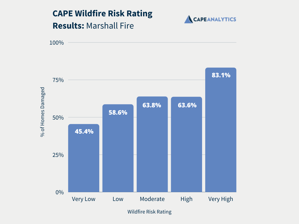
Underscoring the extreme behavior of this wildfire is the high damage rate for even properties that were rated Very Low. In a traditional wildfire, we would expect to see a fraction of these damage rates for Low and Very Low-rated properties.
These findings show that it is necessary for the insurance industry to take on a risk assessment approach that combines all layers of risk, from the regional to the property-specific, to better underwrite in wildfire-prone areas, especially in the face of these extreme weather events.
Interested in learning more about CAPE’s suite of wildfire risk ratings and loss-predictive attributes? Our latest whitepaper explores the various layers of risk assessment and how they can be combined to produce property-specific insights.
Insights derived from Nearmap and other imagery providers.